EVC Species Profiles

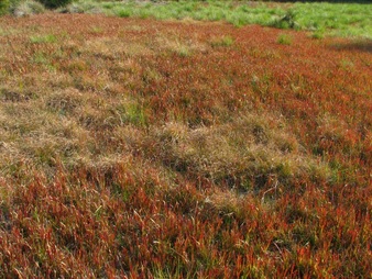
Calcareous Swale Grassland EVC 309, in Rye, Vic
For an short explanation of EVCs, bioregions and conservation status, go to this page
Victoria has a wide range of vegetation types described in terms of ecological vegetation classes. It is estimated that private land supports 30 per cent of the important locations for threatened species with 60 per cent of native vegetation types on private land currently threatened with extinction*
These documents are detailed and accurate lists of the vascular plant species occurring in a given intact EVC on the Mornington Peninsula
There are 32 so far and while not yet a comprehensive list of all known peninsula EVCs, (over a dozen more have been identified since, see the picture at right) new profiles will be added as they become available
Profiles show structure, environment, distribution, bioregional conservation status, nearest EVC relatives, likely adjacent EVCs, a typical site, informational notes, species height and whether the particular species is likely to be available in indigenous nurseries
Many of the listed species, such as geophytes, annuals, rare and difficult to propagate species will not and all plantings tend to be very limited in providing true species diversity, while more sophisticated regeneration techniques, using planting as a last resort or only for species enrichment in areas with depleted seed banks, has proved to yield superior results
See a paper by Dr Jeff Yugovic: Looking after the bush: Natural regeneration is better than planting
To help assess what EVC occurs on a given site, refer to the DSE EVC benchmark series, showing character species, life form cover values, typical species, likely weeds and more... See a sample here
The Biodiversity Interactive Map can display pre-1750 EVC projections for a given area and (generalised and not always accurate, 1:100.000 scale) EVC distributions for any given area. There can be a number of smaller scale or unmapped patches of other communities in the areas mapped as a single EVC
This DSE page, Accessing Native Vegetation Data is also very useful in assessing vegetation distribution and quality
It must be stressed that the benchmarks, even those specific to our Gippsland Plains bioregion, are often incomplete and are merely general guides, while the profiles below are more accurate and detailed
* source: Rural Law Online
Click on a name to go to the profile
or download the entire set as a PDF
| Mornington Peninsula EVC profiles.pdf | |
| File Size: | 136 kb |
| File Type: | |
Our thanks to the Mornington Peninsula Shire Natural Systems Team for making these lists available